Geography and Geology of the Languedoc: Mountains
   the Pyrenees
(
the Pyrenees
( Pirenèus, Pirenèus,
 Pirineus,
 Pyrénées)
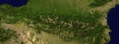
form chain across south-western Europe. This chain
stretches from the shores of the Mediterranean
Sea to the Bay of Biscay on the Atlantic Ocean.
It forms a natural barrier between the Iberian Peninsular
and the rest of Europe, providing a convenient border between
sovereign states. The chain also creates a climatic
divide. Northern slopes receive abundant rainfall while the
southern slopes have a steppe-like climate.
Pyrénées)
form chain across south-western Europe. This chain
stretches from the shores of the Mediterranean
Sea to the Bay of Biscay on the Atlantic Ocean.
It forms a natural barrier between the Iberian Peninsular
and the rest of Europe, providing a convenient border between
sovereign states. The chain also creates a climatic
divide. Northern slopes receive abundant rainfall while the
southern slopes have a steppe-like climate.
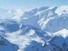
The mountains of Languedoc-Roussillon
reach heights of almost 3000 metres in the Pyrenees, with
the peaks of Canigou (2,784m, or 9,135ft) and Carlit (2,921m).
Click on the following links or more information about the
Pyrenees
( Pirenèus),
and for more about the "mysterious" mountain in
the foothill of the Pyrenees called the Pic de Bugarach
Peaks in the Massif Central to the North of the Languedoc
exceed 1500m notably Mont Lozère (1699m, 5,580ft) and Mont
Aigoual (1565m).
The Black Mountains. The Montagne Noire (Occitan:
Montanha Negra, lit. "Black Mountain") is a mountain
range in located at the southwestern end of the Massif Central
in the border area of the Tarn, Hérault and Aude
departments. Its highest point is the Pic de Nore at 1,210
m.
The mountain is within the Parc naturel régional
du Haut-Languedoc.
Other mountains and mountainous areas. More info tofollow.
Mt Aigoual, Anduze, Florac,
Ganges, Gorge du Tarn, Mt Lozere,
Mende, Millau, St Guilhem le Desert,
St Hippolyte du Fort, St Enimie, Sauve,
Le Vigan
|
|
 Back
to the main Geography page. Back
to the main Geography page. |

|
Next Page: the
Pyrenees 
|
|
|