Geography of the Languedoc: Areas of Special Interest:
The Corbières
The Corbières is one of the wildest areas of France
with one of the lowest population densities. It is picturesque
with wine growing areas alternating with garigue and mountainous
countryside. It is located mainly in the Aude
département and partly in the Pyrénées-Orientales
département.
The River
Aude borders the Corbières to the west and north.
To the south is the River Agly and to the east the the
Mediterranean Sea.
The name Corbières comes from "cor" a pre-Celtic
word meaning "rock" and "berre" from the
River Berre which runs through Durban.
The eastern part of the Corbières with its Etangs,
borders the the
Mediterranean Sea and is called the Corbières maritimes.
It has its own distinctive climate and characteristic vegetation
known as thermomediterranean vegetation.
The Pic de Bugarach
|
The highest point of the Corbières is the pic
de Bugarach (1230 m). It stands far away from the nearby
Pyrenees
to have its own microclimate.
The geology of Bugarach is notable. Its top layers
are older than bottom ones.
Bugarach is easily climbed: A classical route (called
"voie de la fenêtre" referring to a
big hole in a cliff) climbs the South face. One may
walk down the easier route, to the North, to join the
Col de Linas.
In certain climatic conditions clouds form above Bugarach
in the form of halos. The mountain is also claimed to
be so magnetic that aeroplanes never fly over it. This
may help explain why the peak has become wound up in
various mystical movements in the area and associated
with the mystery of nearby Rennes-le-Château.
According to various "mystics" in the area
the peak is a landing site for UFOs. According to others
it hides a great treasure, or a huge cavern. Yet others
say that earth "waves" or "radiations"
(whatever they are) are particularly potent on the top
of Bugarach. Many people climb to peak to spend the
night on the summit, in the hope of experiencing its
mystical power. (At the turn of the Millennium the place
was packed with mystics expecting to be airlifted away
by UFOs and so miss the End of the World, but they walked
down again the following day. A mixed blessing).
When the peak is covered in localised clouds the locals
have a traditional saying: "When Bugarach has got
his hat on, you should put your hat on too".
More on Bugarach
and the Pic de Bugarach 
|
|
 |
Corbieres Wine
Corbières is the largest AOC
(Appellation d'Origine Contrôlée) in the
Languedoc-Roussillon,
encompassing a variety of soil types and microclimates. Wines
from the region are as varied as the Terroir
. The region also experiences widely varied winds. The dry
vent
Cers brings cold weather from the Northwest while the
vent
Marin brings warm, humid air from the Mediterranean
Sea.
Corbieres Terroirs: Terroir de Montagne d'Alaric
This terroir is dominated by the Montagne d'Alaric, along
the Aude valley between Narbonne and Carcassonne.
On damp days, a halo of cloud sits on top of it and the locals
say "Alaric is wearing his hat" (c/f Bugerach).
The mountain is named after the Visigothic
King Alaric II who fought the Franks
in the 5th century. Local tradition has it that he left a
huge treasure buried in the caves beneath the mountain. It
is possible to drive up to the summit by a rocky track from
Moux.
On the south-east slope, overlooking the Gorge du Congoust,
is the ruined chapel of St Michel de Naruze. In dry years,
pilgrims from surrounding villages came up here to pray for
rain up until the 1940s . The valley below the chapel is full
of wild flowers during the spring.
Most of the villages in this terroir are on the N113 which
running along the Aude valley from Lézignan to Carcassonne,
parallel to the motorway.
Fontcouverte lies just off the N113. It has all you
expect of a Corbieres village: a square with a fountain, a
café, a church, and a château. A municipal open-air
swimming pool is fed by a natural spring.
Moux was the birthplace of the poet Henry Bataille
(1872--1922). His tomb is surmounted by an interesting skeletal
statue.
Floure is another village tucked away off the N113.
It also has its own poet: Gaston Bonheur (1923-1980). He founded
a surrealist magazine, Choc, and was director of Paris-Match.
His home was in the château, originally an abbey in
the middle ages. It was converted to a house during the Renaissance.
It is now a hotel and houses a restaurant called Le Poète
Disparu (The Dead Poet)
  Capendu
is the largest village in this terroir. It is a circular village
distinctive of the region and called a circulade.
At the centre is a rock. On it stands the ruined choir of
the 13th century chapel, all that remains of Capendu's medieval
castle. The nineteenth-century church which replaced it can
be seen to one side, making the village elliptical rather
than circular. Capendu
is the largest village in this terroir. It is a circular village
distinctive of the region and called a circulade.
At the centre is a rock. On it stands the ruined choir of
the 13th century chapel, all that remains of Capendu's medieval
castle. The nineteenth-century church which replaced it can
be seen to one side, making the village elliptical rather
than circular.
Clicking on the following link to a page dedicated to Circulades
.
Douzens is a village notable for its windmills. There
is a museum of birds, butterflies and other insects here.
Corbiere Terroirs: Terroir de Serviès
This is a damp, fertile valley sheltered on the south and
west sides by the Plateau de Lacamp and on the north by the
Montagne d'Alaric. This is one of the few places in the Corbières
where you are likely to see sheep. Vines have largely been
replaced here by other crops, so the valley floor is a patchwork
of different colours.
Monze has a medieval packhorse bridge over the Bretonne
on the outskirts of the village.
Mayronnes offers a "Sculpture walk" during
most of July and August. The path through the garrigue is
dotted with modern sculptures by local sculpturs; In June,
there is an event called De Ferme En Ferme, (From Farm
to Farm) organised by farmers in the Val de Dagne. You can
sample local organic produce and join a picnic which includes
a spit roasted ox
In Villar-en-Val, you can visit the 11th-century church
which houses an exhibition on yet another local poet (Joseph
Delteil, 1894 -1978) during the summer season.
The Cistercian
abbey of Sainte Marie de Rieunette is currently being restored.
It is in a remote, wooded valley typical of the sites favoured
by the Cistercians.
At Rieux-en-Val there is a medieval footbridge, a
few hundred yards off the D42. This is a popular film set.
Corbiere Terroirs: Terroir de Lagrasse
  Lagrasse.
Officially one of the most beautiful villages in France (Les
Plus Beax Villages de France), Lagrasse is a small town at
the confluence of two valleys. On one side of the river Orbieu
is the town and on the other the abbey, linked by two bridges
spanning the river. The cobbled market square with its covered
central section hosts craft fairs, bric-a-brac sales, and
produce markets during the summer. The town has become a centre
for potters and artists and many of the medieval houses have
been converted into studios and exhibition spaces. Lagrasse.
Officially one of the most beautiful villages in France (Les
Plus Beax Villages de France), Lagrasse is a small town at
the confluence of two valleys. On one side of the river Orbieu
is the town and on the other the abbey, linked by two bridges
spanning the river. The cobbled market square with its covered
central section hosts craft fairs, bric-a-brac sales, and
produce markets during the summer. The town has become a centre
for potters and artists and many of the medieval houses have
been converted into studios and exhibition spaces.
Click here for more
about Lagrasse 
Ribaute. There are waterfalls in the river at Ribaute.
The river has been dammed by the local council to provide
a pool for swimming, fishing and picnicking. A narrow stone
bridge spans the gorge.
Fabrezan also has a place for swimming; broader and
shallower than at Ribaute, better for those with children.
The village has a broad, shady main street, decent good restaurants,
a café, and shops, also a museum dedicated to Charles
Cros, yet another local poet, but also notable as the inventor
of the phonograph. The local winery takes its name from him.
In August there is a '1900 weekend' which recreates Fabrezan
as it was during the Belle Epoque. It features street stalls,
demonstrations of vanished crafts such as blacksmithing and
lacemaking, and dancing in the streets during the evening.
Camplong d'Aude lies on the flanks of the Montagne
d'Alaric, set back from the main road. It has a village square
which combines all the usual elements of a Midi village: the
spring-fed fountain, a statue of Marianne,
a symbol
of the French Republic and plane trees. There is also
a stone clock tower over the gateway to the château.
Corbiere Terroirs: Terroir de Lézignan
Lézignan-Corbières has a long history.
It is mentioned in a Carolingian document of 806, under its
then name Licinianus. Today it is a market town, a focus not
only for the Lézignan terroir but also the neighbouring
Minervois. The Wednesday morning market invades the main street.
Major road and rail links running along the northern part
of the Corbières connect Lézignan with Carcassonne
to the east and Narbonne
to the west. Lézignan is known as the capital of the
Corbières. Important local organisations (including
the Cru Fitou) have their headquarters here. There is a tourist
office on the main street (tel. 04 68 27 05 42).
In summer there is always something going on here, usually
involving food, wine and outdoor music. At Whitsun there is
a regional produce fair ("Promaude") at the aerodrome
just outside town. In the autumn there is a week-long festival
to celebrate the arrival of the new wine. The Maison Gibert
holds art exhibitions throughout the year. Near the railway
station, there is a museum of wine-making with displays of
old wine-making equipment, clothes, photographs, and documents.
Conilhac-Corbières. Every weekend in November
this community of about 600 people hosts to a jazz festival.
The salle polyvalent (village hall) becomes a smoky jazz club.
Afterwards, the action continues at the nearby 'Cave du Jazz'.
You can get information and make bookings at the Mairie de
Conilhac on +33 (0)4 68 27 08 15 and on the village web site.
Montbrun-des-Corbières, like so many other
town and villages here, is built around the ruins of a château,
perched on a rocky outcrop. A couple of kilometres away is
the church of Notre-Dame de Colombier, an example of early
Romanesque architecture dating from the 11th century. The
belltower is 13th century. Legend has it that the Seigneur
of Montbrun went off on crusade. On his return his now adult
son failed to recognise him and set the dogs on him, mauling
him to death. The son recognised the body the following morning
and was stricken by remorse. At that moment a dove alighted
on the spot so he built a chapel there. The chapel took its
name from the event (Colomier means dove).
Escales is another village with an early Romanesque
church. It has three apses, a large central one and a smaller
one on each side. The altar is constructed from a first or
second-century Roman
sarcophagus.
Corbiere Terroirs: Terroir de Boutenac
Boutenac is not typical of the Corbières with
its wooded hills of parasol pines. This is good wine growing
country. The Château in the village of Boutenac is headquarters
of the Cru Corbières. Around Boutenac and Gasparets,
you will find many Corbières wines. It is this terroir
in the Corbières to produce great wines.
In the hamlet of Gasparets near Boutenac, in a hall
above the wine cave is a collection of stuffed animals, birds
and insects.
Villerouge-la-Crémade is a hamlet on the road
between Ferrals and Thézan. It is dominated by the
ruins of castle, from which you can see a panoramic view over
the countryside. Below, is a chapel, sited on a small mound.
It dates to the 9th century. Inside are the fragmentary remains
of wall paintings dating from the early 12th century.
Saint-Laurent de la Cabrerisse has a church with Visigothic
carvings in the porch.
At Montseret you will find a major bee keeper. The
honey here is richly flavoured with rosemary, thyme, and lavender.
Corbiere Terroirs: Terroir de Fontfroide
 Narbonne.
Narbonne was founded by the Romans
in the second century BC, it became the capital of Southern
Gaul. At the time it was a major port, although it now lies
well inland. Narbonne.
Narbonne was founded by the Romans
in the second century BC, it became the capital of Southern
Gaul. At the time it was a major port, although it now lies
well inland.
Click on the following link for more on Narbonne
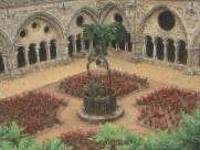
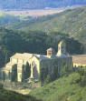 Fontfroide Abbey. The Abbaye de Fontfroide was built in
1145, on the site of an earlier Benedictine foundation. It
became one of the most important and richest Cistercian
abbeys in the south.
Fontfroide Abbey. The Abbaye de Fontfroide was built in
1145, on the site of an earlier Benedictine foundation. It
became one of the most important and richest Cistercian
abbeys in the south.
Click on the following link for more on Fontfroide
Abbey
Montredon-Corbières. Montredon-Corbières
is a typical Corbières village just off the Route Nationale
between Carcassonne
and Narbonne.
Corbiere Terroirs: Terroir de Saint-Victor
This is a large and sparse terroir. Village here are isolated,
generally, surrounded by vineyards. Wines from here are dark
and intense, spicy with the scents of the garrigue.
The Hermitage of Saint-Victor. At 420m (1400 ft),
this hermitage is the highest point for miles around. The
view is spectacular with the Mediterranean
Sea at Port-La Nouvelle visible on one side and the Pic
de Canigou in the Pyrenees
on the other. The tiny chapel, now half-ruined, was kept by
monks from the Abbey
at Fontfroide.
Fontjoncouse. In the village is a restaurant run by
a Michelin-starred chef, Gilles Goujon.
Albas. In Albas you will find a Scottish winemaker,
an anthropologist who called his estate 'Domaine des Pensées
Sauvages', a reference to the French anthropologist Claude
Lévi-Strauss.
Corbiere Terroirs: Terroir de Termenès
Vineyards here rise across slopes between 300 and 450m above
sea-level - about the maximum that vines will produce decent
wine. The name Termenès is derived from the Latin terminus,
because it marked the limit of the early Roman
cultivation. Villages are few in this terroir.
 At
Villerouge-Termenès a Cathar
castle stands in the centre of the village. It has recently
been restored. It offers an audio-visual exhibition telling
the story of Guilhem Belibaste, the last known Cathar
Parfait in the Languedoc to fall into the hands of the
Inquisition.
He was tricked into returning from Catalonia and burned alive
here in 1321. At
Villerouge-Termenès a Cathar
castle stands in the centre of the village. It has recently
been restored. It offers an audio-visual exhibition telling
the story of Guilhem Belibaste, the last known Cathar
Parfait in the Languedoc to fall into the hands of the
Inquisition.
He was tricked into returning from Catalonia and burned alive
here in 1321.
In the summer season, Villerouge-Termenès hosts a
popular three-day medieval festival, recreating the atmosphere
of the village in the Cathar
period. Information is available either from the castle itself
(tel. 04 68 70 09 11), or from local tourist offices.
Click here for more on Villerouge
Termenès
 The
Château at Termes is a ruined castle high above
the modern village of Termes. Termes castle held out against
Simon
de Montfort for months in 1210, eventually succumbing
for lack of water; Having come into the possession of the
French kings later in the 13th century, it became one of the
"five sons of Carcassonne", fortresses protecting
the frontier with Aragon, (Queribus,
Termes,
Aguila,
Peyrepertuse
and Puilaurens).
In the 17th century it was occupied by brigands who used it
as a base from which to raid the surrounding country; Consequently,
the authorities had it razed. The
Château at Termes is a ruined castle high above
the modern village of Termes. Termes castle held out against
Simon
de Montfort for months in 1210, eventually succumbing
for lack of water; Having come into the possession of the
French kings later in the 13th century, it became one of the
"five sons of Carcassonne", fortresses protecting
the frontier with Aragon, (Queribus,
Termes,
Aguila,
Peyrepertuse
and Puilaurens).
In the 17th century it was occupied by brigands who used it
as a base from which to raid the surrounding country; Consequently,
the authorities had it razed.
Click here for more on Termes
Château de Durfort, between Vignevieille and
Montjoi.
Montgaillard a village on top of a rocky outcrop is
said to be frequented by the mitouns (fairies and water nymphs).
Other towns: Vignevieille, Davejean, Rouffiac, Palairac,
Corbiere Terroirs: Terroir de Durban
 The
town of Durban is dominated by a ruined castle. It is the
centre of the sparsest part of the Corbières. Small
villages ere are linked by winding roads. This was once much
more heavily populated. You can see abandoned terraces on
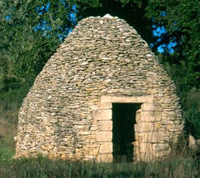
the hillsides supported by low stone walls. There are also
capitelles
here (Prehistoric
cone-shaped drystone shelters), and stone windmills on hilltops.
This was once winter pasture for herds of sheep brought down
from the Pyrenees,
during the transhumance, the capitelles providing shelter
for the shepherds. The
town of Durban is dominated by a ruined castle. It is the
centre of the sparsest part of the Corbières. Small
villages ere are linked by winding roads. This was once much
more heavily populated. You can see abandoned terraces on
the hillsides supported by low stone walls. There are also
capitelles
here (Prehistoric
cone-shaped drystone shelters), and stone windmills on hilltops.
This was once winter pasture for herds of sheep brought down
from the Pyrenees,
during the transhumance, the capitelles providing shelter
for the shepherds.
The way of life here has changed. You will see no sheep now.
Windmills without their sails are still and silent. No grain
has been grown here for centuries. Agriculture has been replaced
by viticulture. Only apiary continues as of old. Rosemary
honey here has been famous since Roman
times.
Durban is a prosperous town on the River Berre. There
has been a settlement here since Roman
times. The château was built by the kings of Aragon.
It was reconstructed in the 16th century as a more comfortable
residence. The Barons of Gléon lived here for 600 years
but the family died out in 1787. The château was sold
in 1873 and, like so many chateaux after the fall of the French
monarchy was used as a source of building stone by locals.
Between Embres-et-Castelmaure and St-Jean de Barrou
you will find the chapel of St-Felix on a small mound,
surrounded by trees in the middle of vineyards. It is overlooked
by the ruins of the château of Castelmaure (a
Moorish Castle) and its deserted village.
The main road through Durban takes you to the inland part
of the Fitou appellation (Fitou consists of two different
areas, one around the village of Fitou on the coast, and the
other inland).
Villeneuve-les-Corbières is the main commercial
centre.
700 hectares at Château Lastours are used as
a training ground for the Paris to Dakar rally.
Apart from Durban, the only other sizeable settlement in
this terroir is Tuchan, on the slopes of Mont Tauch,
917m (2800 ft) high. The name comes from the Occitan
word touch, meaning yew tree, popular here as elsewhere
in pre-Christian times. Only a few of these trees now remain.
At the top of the slope is a tower, La Tour Des Géographes.
It was built 1791, in for use by a group of astronomers who
had been instructed by the Académie Des Sciences just
after the French Revolution to define the Paris meridian.
This was part of a project to define a new unit of measurement
- the metre. It was defined as one ten millionth of the distance
from the Pole to the Equator along the Paris meridian. After
years of work, the standard metre, cast in platinum, was presented
to the National Assembly in 1799. Sadly it was later discovered
that they got it wrong and the metre has since been redefined.
On the slope of Mont Tauch is the chapel of Notre Dame
de Faste. Its presence in this remote spot is explained
by the spring that rises here. It was almost certainly a holy
place before it was Christian place. It is approached by a
track.
Not far from Tuchan is the château of Aguila,
a Cathar
castle. From 1260 it was one of the "five sons of
Carcassonne" protecting the new southern border of the
French Kingdom. Aguilar has a square keep, surrounded by a
wall with circular towers at the corners. There is a small,
simple Romanesque chapel here dedicated to St Anne.
Click on the following link for more on Aguila
Paziols is a small village right on the southern edge
of the Corbières.
Corbiere Terroirs: Terroir de Quéribus
 Peyrepertuse.
The château at Peyrepertuse
dominates this area. It is visible for miles around. The name
Peyrepertuse
is derived from the Occitan
version of pierre percée, "pierced rock".
It is a Cathar
castle built seamlessly onto the living rock. Even on
the approach road from Duilhac it is not easy to see
where the rock stops and the castle starts. The main part
of the château, over 200m long, resembles the prow of
a ship, running along the top of an 800m (2,600 ft) high crag.
The pinnacle is so sheer that it appears inaccessible. In
fact the climb from the car park to the castle is not difficult.
Peyrepertuse.
The château at Peyrepertuse
dominates this area. It is visible for miles around. The name
Peyrepertuse
is derived from the Occitan
version of pierre percée, "pierced rock".
It is a Cathar
castle built seamlessly onto the living rock. Even on
the approach road from Duilhac it is not easy to see
where the rock stops and the castle starts. The main part
of the château, over 200m long, resembles the prow of
a ship, running along the top of an 800m (2,600 ft) high crag.
The pinnacle is so sheer that it appears inaccessible. In
fact the climb from the car park to the castle is not difficult.
Click here for more on Peyrepertuse
 Queribus.
East from Peyrepertuse, you will see the château
of Quéribus
perched on another outcrop. It is the best preserved of these
border castles, and another of the so-called Cathar
castles.
Queribus.
East from Peyrepertuse, you will see the château
of Quéribus
perched on another outcrop. It is the best preserved of these
border castles, and another of the so-called Cathar
castles.
Click here for more on Quéribus
Cucugnan. Below Quéribus
is the village of Cucugnan. The church here has a statue of
a pregnant Virgin Mary, but the town is more famous for a
story, well-known throughout France, called Le Curé
de Cucugnan. The story tells how the priest in the village,
worried by the lack of faith of his parishioners, made his
sermons into terrifying stories of hell. He conjured up such
appalling visions that his parishioners were terrified into
believing. Visitors to the village were henceforth struck
by the piety of its inhabitants. Le Curé de Cucugnan
was originally told in Occitan
by Achille Mir, one of a group of 19th-century writers known
as the "Félibres", dedicated to keeping Occitan
culture alive. The story was popularised by another member
of the group, Alphonse Daudet, in his collection of tales
of Occitan
life Lettres de mon Moulin, "Letters from my Windmill".
(The misleading habit of referring to Occitan
as Provençal
has led people to imagine that Cucugnan must be in Provence).
The village now houses a "pocket theatre", the Théâtre
Achille Mir, in which the tale is regularly enacted. (A ticket
for the theatre entitles you to enter to the Chateau
at Quéribus, and vice versa).
Padern is a romantic ruined castle on a hill overlooking
the village of Padern on the River Verdouble. The castle was
destroyed in the Middle Ages, but rebuilt in the 17th century.
Today it is once more a ruin. It has been called "the
gates of heaven".
Corbiere Terroirs: Terroir de Sigean
The
Languedoc Coast is lined with resorts and long and sandy
beaches. TheMediterranean
Sea is azure and unpolluted. Inland is a classically Mediterranean
landscape, garigue (low-growing oak scrub, wild thyme, and
rosemary, parasol pines and cypresses). Salt water lagoons
(etangs) are a haven for birds. The Massif de la Clape, once
an island, is now a nature reserve containing unique species.
It also has its own wine appellation, and is noted for its
white wines.
 Gruissan
This Mediterranean
Port and traditional fishing village has retained its
character. Gruissan
This Mediterranean
Port and traditional fishing village has retained its
character.
Narrow streets curve around the 13th-century Tour de Barberousse,
from which you can admire a view over the etang. This etang
here is the setting for a firework display on Bastille day,
14 July.
Early in the morning you can go to the fish market at the
port and buy some of the catch as it is brought in from the
boats. Every fishmonger has tuna on display.
Beaches are popular with windsurfers and beach volleyball
players. The Plage Des Pilotis, with its wooden beach houses
on stilts, is the setting for the film Betty Blue directed
by Jean-Jacques Beineix.
Click here for more on Gruissan
Click here for Gruissan
Marina
|