Languedoc Home    Introduction     to See    to Do    Holidays     Langudoc Wine     Languedoc Life    Getting There    Property      History   Geography   Weather 
Cathars of the Languedoc    Cathar Castles    Languedoc Mysteries    Languedoc Books    Languedoc Photos    Articles    Emergencies    Languedoc Guides    More Information

Political Geography of the Languedoc: The département of the Gard ( The Name in Occitan. Click here to find out more about occitan.   Gard)

The arms of the Gard.The département is divided into 3 arrondissements: Alès , Nîmes and Vigan. There are 45 cantons, of which 38 are separate towns. It was one of the original 83 départements created during the French Revolution on March 4, 1790. It takes its name from the River Gard (or Gardon) .

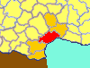
The departmental number of the Gard (which you will find encoded in French numbers - eg telephone numbers, post codes and numbers on motor car vehicle registration plates) is 30.

The département of Gard was created from an eastern portion of the old Province of Languedoc in 1790. Its capital is Nîmes.


The département of Gard is bounded by the Rhône River and the region of Provence-Alpes-Côte d'Azur to the east. On the south, it runs along 10 miles of the Mediterranean coastline. The département's northeastern boarder is the Ardèche River. The département is surrounded by the départements of Hérault, Lozère, Aveyron, Bouches-du-Rhône, Vaucluse, and Ardèche.

The Gard includes within its boundary part of the famous Camargue area at the delta of the River Rhône.

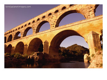
Near Remoulins, the famous Pont du Gard traverses the Gard Rive. This is an ancient Roman aqueduct that once brought water to Nîmes from springs near the picturesque medieval town of Uzès. There are also important Roman architectural remains in Nîmes.

The Gard area was settled by the Romans in classical times. It was crossed by the Via Domitia, constructed in 118 BC.

The highest point in the department is the Mont Aigoual.


Cities: Nîmes (capital of the Gard), Alès , Uzès

Towns: St-Gilles, Beaucaire

Villages:

Ports: Le-Grau-du-Roi, Aigues Mortes

Attractions: Cévennes National Park, Pont du Gard, Via Domitia

Tourist offices:

Click on the following link for Property for sale in the Gard

Click on the following link for Hotels in the Gard Départment Next.

Click on the following link for Naturist Beaches, Resorts and Clubs in the Gard Départment Next.

Click on the following link for Museums in the Gard Départment Next.

Click on the following link for Caves and Grottos in the Gard Départment Next.

Click on the following link for Menhirs, Dolmens and Megaliths in the Gard Départment Next.

Click on the following link for Golf Courses in the Gard Départment Click here for more details of golf clubs in this area

 
Pont Du Gard, Languedoc-Roussillon, France
Pont Du Gard, Languedoc-Roussillon, France Photographic Print
Mayfield, Diana


Find Hotels in the Gard


Back.   Back to: Aude département Up  a level to Political Geography in the Languedoc-Roussillon Nextpage: Hérault département   Forward.
Languedoc Home     About this Site     Site Map     Links     Contact Webmaster     Copyright and Legal     Search site for: 
The Languedoc: property,holidays,climate,naturist beaches,wildlife,wines,history,geography and Cathar castles: the Languedoc Home Page
 Level 1 -  Languedoc Home Page: Languedoc climate & weather, holidays & vacations, tourism & travel, naturism and naturist beaches,property & accomodation, Cathars & cathar castles, food & wine, history & geography, French sports & games, mountains & and lakes, and everyday life in the Languedoc-Roussillon in the South of France.
 Level 2 - Click here to go back to the main Geography page.
 Level 3 - Click here to go back to the main Political Geography page.
 Level 4 - Languedoc website. You are at level 4.
 Level 5 - Languedoc links not available from here.

The Gard (red) in the Languedoc (orange) within France (yellow)).
The Gard
département
Booking.com